
Most people have heard the term topographic survey at some point, usually in connection with a construction project or a development plan. But unless you have worked in engineering, architecture, or land development, you may not have a clear picture of what a topo survey actually produces or why it is so useful. Here is a plain explanation of what a topographic survey covers, what you get from one, and when it makes sense to have one done on a property.
What a Topographic Survey Actually Does
A boundary survey tells you where the edges of your property are. A topographic survey tells you what is happening inside those edges.
Specifically, a topographic survey measures and maps the elevations, slopes, and physical features of a piece of land. When the survey is complete, you have a detailed picture of the land’s surface, including how high or low different areas are, where water naturally flows, what structures and improvements exist, and where trees, utilities, and other features are located.
That information is what engineers and architects need before they can design anything on a piece of land. You cannot responsibly plan a building, a road, a parking lot, or a drainage system without knowing the shape of the ground beneath it.
What Shows Up on a Topographic Survey
A topographic survey captures a lot of information in one document. Here is what you can typically expect to see on the finished drawing.
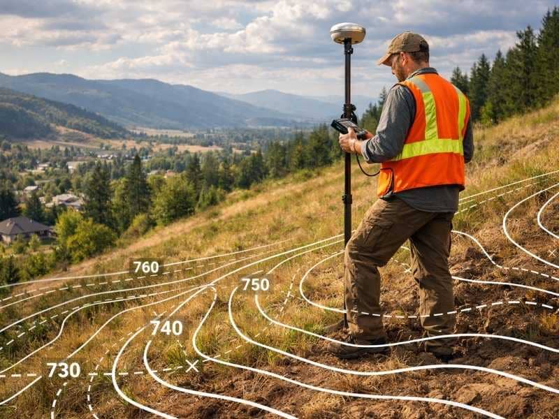
Contour Lines
Contour lines are the most recognizable feature of a topo survey. Each line represents a specific elevation, and the spacing between lines tells you how steep the terrain is. Lines that are close together mean a steep slope. Lines that are spread apart mean relatively flat ground.
For a property in Talladega County, where the terrain can shift from flat to rolling to quite steep within a small area, contour lines give designers a clear picture of what they are working with before a single shovel hits the ground.
Existing Structures and Improvements
The survey records the location and approximate dimensions of any buildings, fences, driveways, retaining walls, and other structures already on the property. This matters for renovation projects and additions just as much as it does for new construction.
Trees and Vegetation
Significant trees are typically located and noted on a topographic survey. This is important for site planning because large trees affect grading decisions, drainage patterns, and in some cases, permit requirements.
Utilities
Above-ground utilities like power lines, utility poles, and visible infrastructure are recorded. Some surveys also note the location of underground utilities based on markings or available records, though locating buried utilities precisely usually requires a separate process.
Drainage and Water Features
Natural drainage patterns, low spots, ditches, streams, and any other water features on or near the property are documented. In Talladega County, where properties near Talladega Creek and other waterways can have complex drainage conditions, this part of the survey is especially valuable.
Who Uses a Topographic Survey and Why
A topographic survey is most commonly ordered by engineers, architects, and developers. But property owners sometimes need one too, depending on what they are planning.
Engineers
Civil engineers use topo surveys to design grading plans, stormwater systems, road alignments, and utility layouts. The elevation data tells them how much earthwork will be needed to prepare a site, where water will flow after a rain event, and whether the natural drainage patterns create any challenges for the project.
Architects
Architects use topo surveys to understand how a building will sit on the land. A house designed for a flat lot looks and functions very differently from one designed for a sloped site. The topo gives the architect accurate ground truth before the design process begins.
Developers
Before a piece of land can be developed into a subdivision, a commercial site, or any other use, the developer needs to know what the land actually looks like. A topographic survey is one of the first things ordered during the due diligence phase of a development project.
Property Owners
If you are planning a significant landscaping project, adding a pool, managing a drainage problem on your property, or dealing with erosion, a topographic survey can give you the information needed to address it properly rather than guessing.
How a Topographic Survey Is Done
The field crew uses surveying instruments to collect elevation readings, called shots, at regular intervals across the property. The spacing of those shots depends on the required accuracy of the survey. A survey needing one-foot contours might require shots every 20 to 30 feet, with additional shots taken wherever the terrain changes abruptly.
These points where the terrain changes direction sharply are called breaklines. The back of a curb, the centerline of a ditch, the edge of a retaining wall. Breaklines are collected carefully because they define where the contours change, and missing them produces an inaccurate picture of the land.
After fieldwork, the collected data is processed and used to generate the contour lines and feature locations that appear on the finished drawing. The result is a precise, scaled map of the land’s surface that designers can work from directly.
Topographic Surveys and Talladega County Terrain
Talladega County has a varied landscape. Parts of the county are relatively flat, particularly in and around the city of Talladega itself. Move out toward the edges of the county and the terrain gets more interesting, with rolling hills, creek drainages, and steeper slopes that require careful planning for any kind of development.
That terrain variation is exactly why topographic surveys matter in this area. A site that looks buildable from the road can turn out to have significant elevation challenges once a proper survey is done. Finding that out during the planning stage is far better than discovering it after construction has started.
Frequently Asked Questions
Do I need a topographic survey before building a house?
Not always, but it depends on the site. If your lot is flat and simple, a builder may be able to work from existing information. If the site has any significant slope, drainage features, or grading requirements, a topographic survey is strongly recommended before design begins. It can prevent costly surprises during construction.
Can a topographic survey be done at the same time as a boundary survey?
Yes, and combining them is often the most efficient approach. When both surveys are needed for the same property, having one firm handle both means the fieldwork overlaps and the total cost is usually lower than ordering them separately.
How accurate is a topographic survey?
Modern topographic surveys using total stations and GPS equipment are highly accurate, typically within a fraction of a foot for horizontal positions and elevations. The accuracy required for a specific project is determined by what the survey will be used for, and the surveyor will conduct the fieldwork to meet that standard.
What is the difference between a topographic survey and a topo map?
A topo map is a general reference document, often produced by government agencies, that covers large areas at a relatively small scale. A topographic survey is a site-specific, detailed document produced by a licensed surveyor for a specific property or project. The two are not interchangeable for design or construction purposes.
Does a topographic survey show property lines?
Not necessarily on its own. A topographic survey focuses on surface features and elevations. If you need both the boundary lines and the topographic data shown on the same drawing, you need to request a combined boundary and topographic survey. Many projects require both, and it is worth clarifying upfront which deliverable your engineer or architect needs.